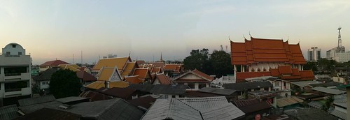
A City of Angels, built by angels, the central city of governance,
Brilliant and beautiful temples and palaces, the capital of Thailand
It’s probably not surprising that the slogan for Bangkok has no trace of humans in it.
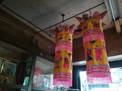
“There are many impacts on the environment. Seven years I have had to endure traffic jams, dust, and no customers.” The complaints of Chatchai Toemthiraphot, 51, owner of a shop selling guardian spirit lanterns used in Chinese shrines, as well as various cameras. He is a member of the Charoen Chai community and has lived there for 3 generations. 7 years ago it fell into the path of the construction of Wat Mangkon station on the Blue Line underground railway.
After the underground railway construction project, the Chumbhot-Pantip Foundation, the owner of the land, cancelled rent contracts with residents of Charoen Chai community. They stay by paying the rent from month to month without knowing if they can still live there next month. The status of long-standing renters did not lead to negotiations with the land owner.
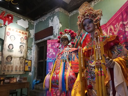
Ban Kao Lao Rueng (Historic House)
Charoen Chai, an old community of around 80 households, is a reflection of the many communities in the inner capital that have been trying to live with the changes around them. They are also being merged as one part of the new master plan to develop and conserve Krung Rattanakosin that was expanded as far as Phadung Krung Kasem Canal.
Learn about the Krung Rattanakosin Master Plan; sneak a peek at the new volume that has yet to be disclosed
- The Master Plan for the Conservation and Development of Krung Rattanakosin is a plan by the Committee for the Conservation and Development of Krung Rattanakosin and Old Towns (formerly called the Krung Rattanakosin Project Committee, which expanded its jurisdiction in 2003 to old cities in other provinces).
- The Master Plan serves as a framework for the conservation of the cultural heritage of Krung Rattanakosin.
- The plan in current use was approved by the Cabinet in 1997
- In 2017, the Office of Natural Resources and Environmental Policy and Planning (ONEP), the secretariat of Krung Rattanakosin Committee, hired Chula Unisearch of Chulalongkorn University to draft a new master plan.
- Currently ONEP has sent the finished draft master plan to the Office of the National Economic and Social Development Council (NESDB) for consideration before submission to the Cabinet for consideration as the last step in the procedure.
- The NESDB received the plan in September 2017. According to the stipulated timeframe, the NESDB has 30-45 days to consider the plan, but as of today there has still been no response from them.
- When asked, the NESDB said that they have to wait for the formal announcement of the National Strategic Master Plan. When it is announced, the Krung Rattanakosin plan, which is a lower level plan, will be considered so as to comply with the national plan. The National Strategic Master Plan is expected be announced by the end of February 2019.
What does the new Master Plan look like?
The key point of the new Master Plan is its expansion over a larger area:
1. Inner Rattanakosin
2. Outer Rattanakosin
3. The Thonburi bank opposite Rattanakosin
4. The contiguous area around Outer Rattanakosin, from line of canals around Rattanakosin to Phadung Krung Kasem Canal
5. The contiguous area around the Thonburi bank opposite Rattanakosin.
The expansion to Phadung Krung Kasem Canal will expand the Krung Rattanakosin boundary to cover around 8,000 rai or 12.8 km2, up from the current 5.8 km2, and will include at least 77 communities within its area.
The new Master Plan has yet to be disclosed to the public since it has yet to be approved by the Cabinet.
However, Borvornvate Rungrujee of the Krung Rattanakosin Committee, received additional information that the Master Plan was expanded to Phadung Krung Kasem Canal because this canal was dug during the reign of King Rama IV as an expansion of the capital in the old manner through waterways. This was probably the last time before the change to expansion by roads in the reign of King Rama V.
The most obvious and well-known example of the impact of the current (1997) Master Plan is the demolition of the Pom Mahakan community, one of the old residential areas, and its replacement by a small park, for the reason that the people in the community were not the original residents. The real owner of the land had already received compensation under the Royal Decree on Land Expropriation B.E. 2535 (1992). The negotiation process, including attempts over the past 26 years by people inside and outside the community to revive various cultural identities, was unable to change the Bangkok Metropolitan Administration (BMA)’s determination to build a park according to the plan. This resulted in various old communities in Bangkok losing faith in this plan.
There (probably) won’t be another demolition like Pom Mahakan
Borvornvate emphasized that under this new plan which is about to be born, there probably will not be a repetition of community demolition and replacement with a park like Pom Mahakan, since there are only small projects.
“There shouldn’t be another case (like Pom Mahakan). We discussed that in some areas if there is a park, the type of ‘park’ we should be looking at aren’t big ones but small spaces. Just one unit of a rowhouse can be made into a small park squeezed in, but as far as we checked, there is no more space. They’ve all turned into people’s houses. There was only Pom Mahakan that was royal property,” said Borvornvate.
Landscaping of a small park in Pom Mahakan community
The experience of Pom Mahakan makes the people’s sector perhaps view the Master Plan as a “risk”. One of the communities may be demolished to set a new rule. Even then, the viewpoints of those who have studied and drafted the new Master Plan are different, seeing that it will instead be a way to help protect the original communities.
Assoc. Prof. Dr. Wannasilpa Peerapun, lecturer at the Faculty of Architecture, Chulalongkorn University and Director of the Master Plan Project of Unisearch, Chulalongkorn University, the academic agency that was hired to draft the new Master Plan from ONEP, said “If the communities are to be kept, the only method is to control things so that no giant projects come about. In fact there are some, but not a lot. Especially large projects cannot be done, and buildings can’t be any taller than 5-7 stories. If you do not set out a framework in the form of a master plan like this, in a while, what if there’s an Iconsiam built in the middle of Yaowarat? This isn’t extreme conservation to the point it turns into a museum. It is not development until the value of the cultural heritage disappears. We try to balance things out.”
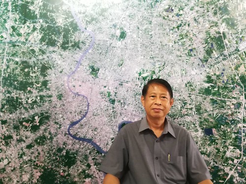
Assoc. Prof. Dr. Wannasilpa Peerapun
Wannasilpa emphasized that in practice, it is not the case that the enactment of municipal laws and their enforcement in the plan by the BMA and the conservation approach set out here can order a private organization not to demolish a community which is renting property.
It is also necessary to note that currently there are 3 underground lines that enter the Krung Rattanokosin area: the Blue Line (Hua Lamphong-Tha Phra-Bang Khae; Hua Lamphong-Tha Phra-Bang Sue); the Orange Line (Yommarat-Bang Khun Non); and the Purple Line (Tao Poon-Rat Burana).
Assoc. Prof. Dr. Yongtanit Pimonsathean, a member of the Krung Rattanakosin Committee said that the new Master Plan prioritizes communities, buildings, and homes that are not important at the national level but are treasures of the locality. Old houses were surveyed, and thousands of old buildings were detailed for conservation privileges for the residents and owners of these houses, such as tax abatements or the sale of rights to private developers to further develop the area.
Too little time for participation.
The new Master Plan has had a total of 9 public hearings, 3 large meetings, and 6 focus group discussions. Even the drafters of the Master Plan themselves see that there is a problem with participation with the time for preparation being too short.
Wat Sunthorn Thammathan Community, an area included in the Master Plan without any participation from the community
Wannasilp indicated the time frame problem when ONEP specified that the team had to finish drafting the Master Plan in 270 days, or finish the work within 1 budget year. A time frame this short mean the management of the hearings was limited. He estimates that to do it properly, at least 2 years should be spent to study such a large area.
“A large plan needs to be very careful. The number of hearings is not as important as their effectiveness. If the meetings are held too often, and a new idea hasn’t had time to be considered before the next meeting, it may not be beneficial. There should be some time for thoughts to settle and new things to come up. Hurrying meetings leads to fewer suggestions. The residents have to work. If meetings are held close to each other, the old people won’t come. If a little time is left in between and we communicate through Facebook, then if there is anything, it can be collected together. I believe that there will be many more new ideas.”
Taking a look at a hot project, Chao Phraya for All
Another project which has been hot since last year and is related to old communities also with a conservation perspective, is the Chao Phraya for All riverside walkway project with a value of over 8,000 million baht. The BMA is preparing to build a 7 km cycle path along both sides of the river. This project is interesting because on one side it has received an international award for participation while on the other side many groups have raised their voices that they were almost unable to make any suggestions, and did not receive even basic information.
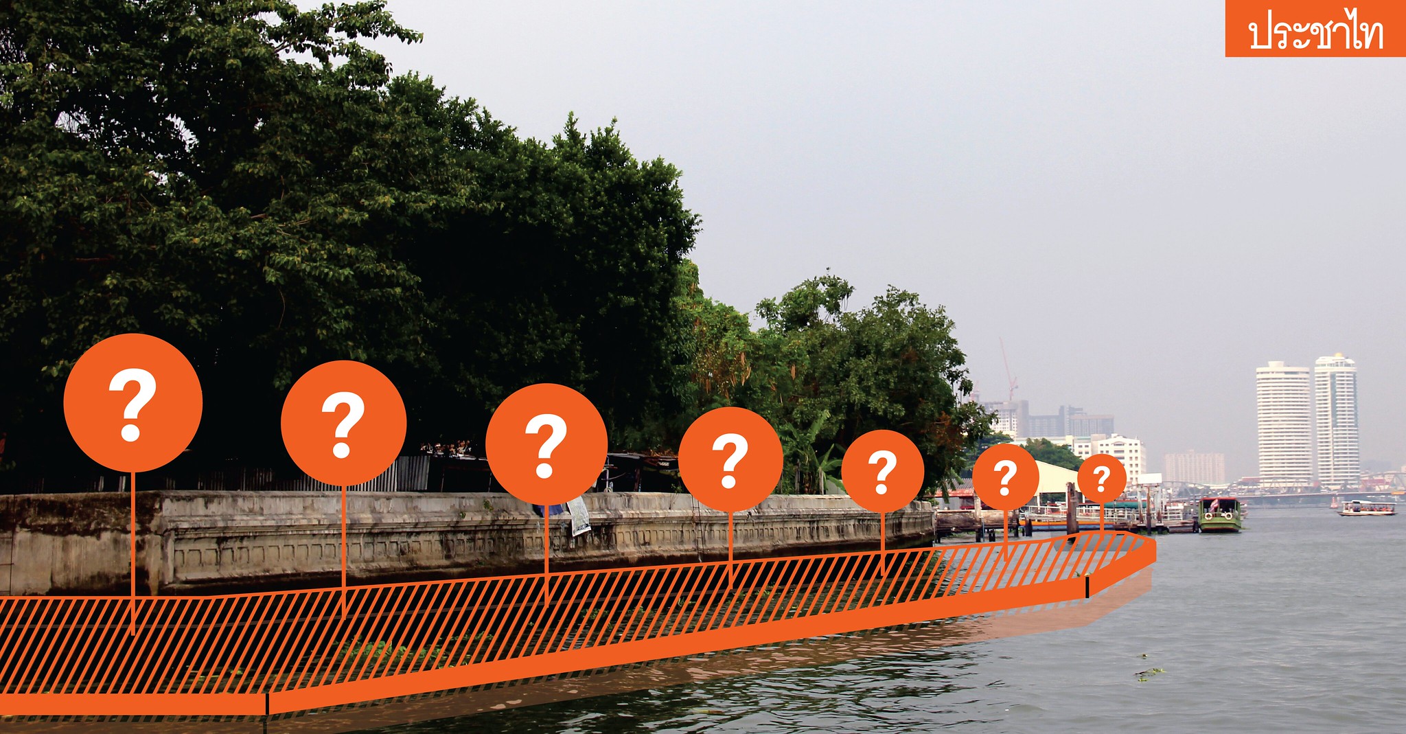
Chao Phraya for All riverside walkway project
Source: Nattapon Kaikeaw
Learn about the Chao Phraya walkway at a glance
The Chao Phraya walkway is 1 of the 12 plans in the Chao Phraya for All project of the Ministry of Interior, approved by the Cabinet on 9 December 2014. Since then the BMA Department of Public Works has been responsible for the project
Initially the project was expedited. A contract was signed in December 2017, specifying that construction will take 18 months (January 2016 to July 2017), and asking the Ministry of Interior, Ministry of Defence, Ministry of Agriculture and Cooperatives and other related agencies to integrate the Chao Phraya Walkway project with other projects, such as the Bangkok Fishing Pier, Bangkok Shipyards, etc.
12 plans to develop the Chao Phraya river or Chao Phraya for All include: 1) the Chao Phraya riverside walkway; 2) improvement of the embankment landscape ; 3) development of the port, 4) development of river pavilions; 5) development of public spaces; 6) development of access to the area; 7) development of historic canalsides; 8) development of community areas; 9) conservation of religious sites, 10) development of recreational areas and riverside parks; 11) development of landmarks; 12) development of a pedestrian bridge across the Chao Phraya River.
The first phase will consist of projects 1-6. As regards the walkway, there was a wave of criticism leading to adjustments up until November 2018. when there was news that the project was at the stage of requesting approval from the Ministry of Interior to tender for estimates of the construction of the pilot phase, starting from the Rama VII Bridge to Phra Pinklao Bridge, 7 km on each side, together making it 14 km from a total distance of 57 km, with a budget of around 8,363 million baht. The project will be divided into 4 contracts:
Phase 1 from Rama VII Bridge to Samsen Canal: 1,770 million baht budget
Phase 2 from Samsen Canal to Phra Pinklao Bridge: 2,470 million baht
Phase 3 from Rama VII Bridge to Bang Phlat Canal: 2,061.5 million baht
Phase 4 from Bang Phlat Canal to Phra Pinklao Bridge: 2061.5 million baht
Later, the Ministry of Interior and BMA hired King Mongkut's Institute of Technology Ladkrabang (KMITL) and Khon Kaen University (KKU) as advisers to survey, design and create the project master plan with a 120 million baht budget.
Information from the Landscape Architecture group, Office of Architecture, Fine Arts Department, indicated that throughout the 14 km path, there are 32 important communities on the banks of the Chao Phraya. A survey by the BMA found that 273 households in 15 communities had built constructions encroaching onto the Chao Phraya river, and there were 9 other jetties. So the district offices responsible, Dusit, Bang Sue and Bang Phlat, together with the Community Organizations Development Institute (CODI), were told to investigate their rights, conduct a survey, evaluate construction costs, and remove and relocate to new residences those that were affected.
From the presentation video of the Chao Phraya for All project, the basic information displayed shows that the pathway will have a height of 2.25 metres above sea level and width of 7-10 metres, which will not affect the navigation of vessels on the Chao Phraya river where the narrowest part is 200 metres at Sangwet Witsayaram temple and the widest part is 380 metres at Tha Wasukri.
Asst. Prof. Antika Sawadsri, Dean of the Faculty of Architecture, KMITL, who researched, designed and was spokesperson for the Chao Phraya for All project, explained at that first the BMA Department of Public Works had hired a private organisation to build a road for cars but strong resistance led to a study of the impact by an academic institution instead. An observation made by Antika is the rush to do the impact study and design, and the purpose of the impact study already gave the answer that ultimately there would have to be a long road along the Chao Phraya river.
“A project of this scale usually takes over 2 years of study; study, design and revision, and more public hearings, which nobody has done. Many universities didn’t do it. At that time everybody already knew that the first proposal of a road for cars wouldn’t be good, so when no one in the BMA accepted the study, the TOR were amended to a walkway”.
“In the TOR it was written that the design had to be a walkway on both sides of the river since the state wanted to solve flood problems. Another thing is using the walkway to stop anything else from encroaching on the public space. At first they started from building walls as flood barriers without much design; it was just a cement wall. The scenery was all destroyed. Later on, they had studies of models, but they made the walkway very narrow to avoid river encroachment. This was the restriction. However, the freedom is that they didn’t say how long the walkway had to be, or that it had to be made of cement.”
The opposition that led to an Administrative Court case
The movement opposing the Chao Phraya walkway project appeared as soon as the project started. Paranee Sawasdirak, a city planning academic in the Civil Society Planning Network and a leading figure in the protest, said that there have been many studies of projects concerning the Chao Phraya river: a riverside walkway by the Office of Transport and Traffic Policy and Planning (OTP), BMA studies on water drainage and communities, the Fine Arts Department of the Ministry of Culture’s study of whether it is a world heritage. You expect to see study results reviewing various plans, which plan should be improved and which plan is good or bad for the Chao Phraya, but there weren’t any presentations about this.
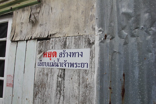 An opposition sign: "Stop Construction of the Chao Phraya Riverside Walkway."
“What they showed us was maps, work plans, where the walkways are, where the jetties are, where the community plans are. They say this is the master plan, but it’s not. It’s just a presentation of the project. A master plan also needs to have an analysis of the users. How many people are estimated to use the cycling path? What are the advantages? What are the impacts? Studies on the appropriateness in terms of finance, an economic study on whether the investment of this amount of money is worth it in terms of social, economic and cultural aspects. There weren’t any proposals on this in the past hearings,” Paranee said.
Another important matter is the Environmental Impact Assessment (EIA) study. Paranee said that the project adviser claimed from the start that a cycle path was not in ONEP’s specifications for the EIA, but this project is not just a cycle path but a project comprising 12 plans. There should be a study on the accumulated impact of all the plans.
“But in the end, they said they’ve already done it and handed it to ONEP. We only know that the EIA report didn’t pass, there was no disclosure of its content. There are only the opinions from related agencies saying that information is still incomplete on the environmental and cultural impact, and they aren’t continuing with the EIA. The worrying thing is ONEP themselves said that this project doesn’t require an EIA. ONEP is only looking at the cycle path, meaning that the 12-plan megaproject lacks an Environmental Impact Assessment,” Paranee said.
All these reasons transformed into a lawsuit at the Administrative Court when a total of 6 representatives from the River Assembly, the People’s Art and Culture Foundation, the Civil Society Planning Network and the Riverside Community Network, one of them being Paranee, filed a lawsuit against 4 state agencies: the Cabinet, the Chao Phraya for All Project Steering Committee, the Ministry of Interior and the Bangkok Metropolitan Administration, calling for the cancellation of the Chao Phraya riverside walk project.
The main topic leading to the lawsuit was injustice in the participation process and the right to information that the community and related parties should have. When there is no information, the participation process is meaningless.
A different viewpoint on conservation: Fine Arts protests; Public Works stands firm
Information from the Landscape Architecture Group indicates that there are 34 registered and 44 unregistered historic sites within the 14-km pilot project. The Department of Public Works has been in continuous contact with the Fine Arts Department, but it seems like communication is through different channels.
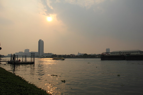
Chao Phraya River on the peak day for PM2.5
The Fine Arts Department said that they do not agree with the construction of the Chao Phraya walkway from Rama VII Bridge to Somdet Phra Pinklao Bridge, since it will cause the following impacts:
1. Construction to solve the problem of encroachment on the riverbanks is itself an act of encroachment on the Chao Phraya river
2. The construction impacts the connectivity to the river of historic sites and community lifestyles whose original relations are with the river. Information on the historic sites that are within the area of the project according to the analytical study is not in accordance with the physical form that was presented.
3. The construction negatively impacts the cultural landscape on the Chao Phraya riverside, hiding the view of historic sites from the river bank, not in accordance with the original context.
The Department of Public Works then clarified this matter by referring to the consideration at the 5th National Reform Steering Assembly meeting on 16 July 2018 chaired by Gen Prawit Wongsuwan where there was acknowledgement of the progress of the pilot project’s first phase (Rama VII Bridge to Royal Irrigation Department) and the third phase (Rama VII Bridge to Bang Phlat Canal) that is already outside the Krung Rattanakosin Island area. The meeting resolved that the Fine Arts Department should join the BMA to carry out the Chao Phraya for All project on condition that the landscape design is adjusted to be suitable for 3 historic sites: Bang O Mosque (Thonburi side), Kaeo Fa Chula Mani temple and Chan Samoson temple (Phra Nakhon side).
If we expand on the reasons in response to the Fine Arts Department provided by the BMA Department of Public Works, the interesting thing is that the Department of Public Works still confirms that the BMA was assigned by the Ministry of Interior to carry out the Chao Phraya for All project according to the Cabinet resolutions of 9 December 2014 and 12 May 2015, stating that the walkway project plan must be built on the Chao Phraya river, because if it is built on the ground, the state would need to expropriate private land by the river, which will take a long time. People have been inconvenienced and there have been studies on the suitability and mitigation of impacts that may occur, and the maximum overall benefit to the people.
To the opinions of the Fine Arts Department on the impact on accessibility and the relationship to the river of historic sites and way of life of communities, the Department of Public Works explained that the communities, households and businesses on the river bank can still live and carry on their jobs or operate businesses as before. But they will be able to access the river more conveniently, creating a benefit to the people since they are able to access more of the Chao Phraya river to view the beautiful landscape and arts and culture on both sides of the river. The communities’ economy will also improve from more tourist visits. Also the Chao Phraya river currently has a flood embankment at a height of 2.8-3.5 metres above mean sea level, preventing people living by the river from being able to fully view the whole of the Chao Phraya river.
Regarding historic sites, construction will pass through unregistered historic sites only. The level of construction will be around 1.25 metres lower than normal flood embankments, so will not block the view of historic sites at all. And development of the area has considered the cultural and architectural context of the riverside. When the development is finished, historic sites will be more easily accessible.
Vasu Poshyanandana from the Fine Arts Department explained that the two sides do not understand each other on the concept of historic site conservation.
“When the walkway passes in front of the temple, they will build a Thai pavilion like a temple. This is a new construction, encroaching on the river and blocking the view. In front of the mosque it would be like a mosque. Is this really mitigating impacts? Actually, the impact is being in the way, not allowing the original to be in the same context it once was in, which is next to the river, but you solve the problem by designing it to be Thai, be Chinese, be Islamic, which is not a way to solve the problem.
“In the Fine Arts Department, we’ve spoken quite clearly, specifically on the topic of historic sites alone, for example, the area in front of Ratcha temple (Ratchathiwat temple) where according to history near the Ratchathiwat temple jetty there used to be a floating church. In the past when a ceremony was held in this church, water from the Chao Phraya river was used as a water boundary (water chapel). It had that kind of history. If you build a walkway or a new pavilion that you say will be designed to imitate Ratcha temple, which was influenced by Khmer art, that means the pavilion at the Ratcha temple jetty will become like a stone castle, and then what would happen to the value of Ratcha temple?” Vasu said, speaking as a Fine Arts Department official.
Different takes on participation
The BMA Department of Public Works said that there were 400 visits to the area to listen to the people’s opinions . There was large-scale participation, where they received cooperation from the general public, the riverside communities and stake-holders who continuously provided information and opinions.
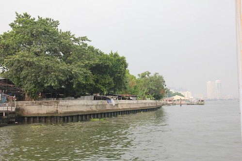 Flood embankment as high as the roofs of houses, built in 1996 and heightened due to the 2011 floods
The participation process of the Chao Phraya for All project was accepted at an international level, as seen by the gold medal received from International Association for Universal Design (IAUD), an organization from Japan promoting Universal Design. In the category of Regional Planning, the IAUD website gives the opinions of the judging committee: “The jury was impressed with the ambition of the project, the coherence of the planning process and the exemplary level of user-involvement and consultation. In particular it praised the emphasis on preserving and respecting the diversity and uniqueness of local and regional human environments, which reflect the diversity of human population and cultures.”
Antika explained about the participation process and the field work which she herself also took part in.
“We had 3 major public hearings. Other than that, they were small meetings. There was a diverse range of opinions. The problem is that we have to go back to 3 years ago. The trend was to resist, whether it’s political resistance, resistance against the military or protest against the project itself. It meant that the truth of the other side had no space at all.”
“We sat with many communities. They agreed that the project would develop prosperity in the area, because it’s been left as ‘the back of the house’ for a long time. Before, people used the river. The river was the front of their house. Now people use the road, the road becomes the front of their house. Various services from the state often don’t reach the back. The community looks after itself; blocked water, garbage under the house, there are many of these problems. Some people are also happy that there is a project since some places that have been hidden will be more accessible, and their value will increase,” Antika said.
When we spoke with the side opposing the project, especially on the topic of the walkway, it was almost like a different story.
Paranee talked about her experience at the 3 public hearings, saying that the opposition side did not receive enough information to express their opinions clearly and in the midst of the rushed procedure, they didn’t get any chance to express their opinions.
“During the project orientation, it was like public relations first. At the meeting at the cultural centre, we protested about the TOR. They (Dept. of Public Works) said that it could be done. Thailand has a need for everyone to access the river; they do not need to waste their money on expensive riverside restaurants. We protested that accessing the river doesn’t mean there needs to be a walkway all along the river. After the first public hearing we went and submitted a protest in writing for a review of the project. We hadn’t yet seen all the studies. They only distributed 1-2 pages of PowerPoint slides about what they were going to do.”
“At the second public hearing, according to the TOR, the draft master plan should already have been completed. They organised an area under the Rama XIII Bridge. It turned out that on that day there was an exhibition under the bridge on what the 12 master plans will be doing and where. We asked them to explain the studies leading to the proposal in each plan, but they didn’t. Then they divided the community groups to fill in forms on what they liked or didn’t like. We objected, asking how this kind of hearing would create participation. There was no answer. People in the community do cooperate. Even if they don’t agree, they still provide all the information about what they want and don’t want, but it’s like asking for their opinions on the basis that whatever happens, there will be a riverside walkway.”
Paranee also added that the claims they made about having more than 100 hearings was because they also counted their talks with companies, hotels and various groups, but in the end the people still don’t know the results of those talks.
Voice from the riverside community
Rawiwan, a member of a riverside community, added that “the last forum was held at the Navy. The Ban Pun community sent a letter that they wouldn’t participate since in the past 2 hearings we were pushed and pressured into not expressing any opinions. The large networks still participated but even though they raised their hands, they were as before not allowed to speak, only listen.”
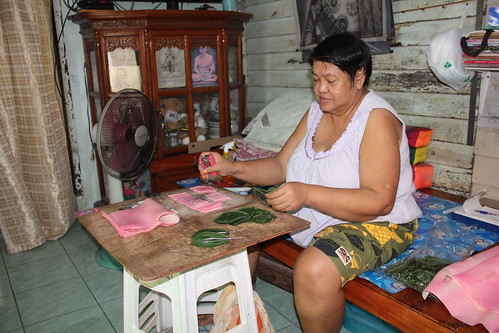 Rawiwan, an owner of a third-generation artificial flower business
Rawiwan, who used to be a community board member, said that there had never once been a compromise plan for the long walkway, and the area survey to assess the impacts was done in a discriminatory way. Ban Pun and Bang Lamphu communities were surveyed only once each since information was produced to strongly oppose the project, but some areas that tended to be in agreement were surveyed all 3 times.”
“We’re not thinking of designing anything within this framework. Is there another option? We can meet halfway. What about a small walkway? They say it’s not in the plan. We told them that the community wants a riverside pavilion. They say there’s no budget.”
Rawiwan, one of the people that had filed the lawsuit with the Administrative Court, said that even though today the cycle path along Chao Phraya river isn’t passing in front of the flood embankment of Ban Pun community yet, various procedures has already divided the community.
These are two big plans dealing with areas in Bangkok where there remain questions about the participation process of community members in the plan, as well as all Bangkokians. We should keep an eye on how, after the new government, the Krung Rattanakosin Master Plan will reach the Cabinet, be announced or adjusted. As for the Chao Phraya walkway project, how will the Administrative Court rule? Can construction begin among voices of resistance from many sides?

Prachatai English is an independent, non-profit news outlet committed to covering underreported issues in Thailand, especially about democratization and human rights, despite pressure from the authorities. Your support will ensure that we stay a professional media source and be able to meet the challenges and deliver in-depth reporting.
• Simple steps to support Prachatai English
1. Bank donation via the "Foundation for Community Educational Media (FCEM)", Krungthai Bank, account number 091-010-4328, Swift Code: KRTHTHBK
2. Or, Transfer money via Paypal, to e-mail address: [email protected], please leave a comment on the transaction as “For Prachatai English”